Environment · Public data
Earthquakes
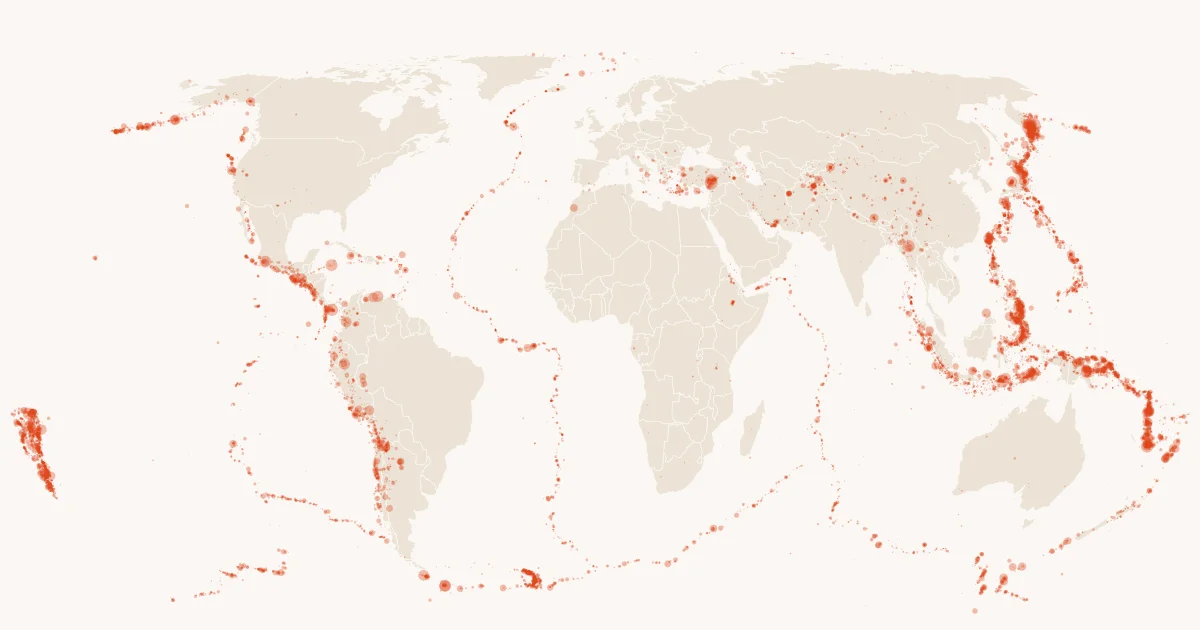
Every magnitude 4.5+ event since 2000, where and how deep.
USGS Earthquake Hazards Program (FDSN event service) · Public domain · commons_pubdata.environment.earthquakes
- 187,658rows
- Worldwidecoverage
- Dailyrefresh
- 13 Oct 2026last refreshed
- 8.1 MBtable size
| event_id | event_time | latitude | longitude | depth_km | magnitude |
|---|---|---|---|---|---|
| usp0009kjw | 2000-01-01 02:19:26.99+01 | 41.927 | 20.543 | 10.0 | 4.5 |
| usp0009kk5 | 2000-01-01 05:30:10.37+01 | -26.012 | -68.803 | 105.0 | 4.5 |
| usp0009kk8 | 2000-01-01 06:24:35.29+01 | 36.874 | 69.947 | 54.3 | 5.1 |
| usp0009kkb | 2000-01-01 06:58:19.78+01 | -60.722 | 153.67 | 10.0 | 6.0 |
| usp0009kkh | 2000-01-01 08:50:00.39+01 | 8.37 | 126.336 | 100.7 | 4.5 |
| usp0009kkj | 2000-01-01 08:51:08.02+01 | -23.319 | -179.978 | 537.8 | 4.6 |
| usp0009kkm | 2000-01-01 09:25:52.8+01 | -3.207 | 148.877 | 10.0 | 4.5 |
| usp0009kks | 2000-01-01 12:22:57+01 | 46.888 | -78.93 | 18.0 | 4.7 |
The first rows of environment.earthquakes as of 13 Oct 2026.
Query it with DuckDB.
Bash
lhbox duckdb --catalog commons/pubdata
SQL · The strongest earthquake per year
SELECT year(event_time) AS year, max(magnitude) AS max_magnitude
FROM commons_pubdata.environment.earthquakes GROUP BY 1 ORDER BY 1;
SQL · DuckDB 1.5.5 or newer, no key
INSTALL iceberg; LOAD iceberg; INSTALL httpfs; LOAD httpfs;
CREATE SECRET pubdata (TYPE S3, ENDPOINT 'lakehousebox-public-data.b-cdn.net', URL_STYLE 'path', REGION 'us-east-1');
ATTACH ':memory:' AS pubdata;
CREATE SCHEMA pubdata.environment;
CREATE VIEW pubdata.environment.earthquakes AS SELECT * FROM iceberg_scan('s3://commons--pubdata/environment/earthquakes');
SQL · The strongest earthquake per year
SELECT year(event_time) AS year, max(magnitude) AS max_magnitude
FROM pubdata.environment.earthquakes GROUP BY 1 ORDER BY 1;
Read it where you work.
Public, read-only data. With an account, lhbox duckdb attaches the catalog as commons_pubdata; an agent with the LakehouseBox connector opens it with open_public_catalog("commons/pubdata"). Without one, DuckDB reads the public files directly.
Example queries
The strongest earthquake per year
SELECT year(event_time) AS year, max(magnitude) AS max_magnitude
FROM commons_pubdata.environment.earthquakes GROUP BY 1 ORDER BY 1;
Events within ~300 km of your sites in the last year
SELECT s.site_id, count(*) AS quakes, max(e.magnitude) AS strongest
FROM my.sites AS s JOIN commons_pubdata.environment.earthquakes AS e
  ON abs(e.latitude - s.lat) < 2.7 AND abs(e.longitude - s.lon) < 2.7 / cos(radians(s.lat))
WHERE e.event_time >= now() - INTERVAL 1 YEAR
GROUP BY 1;
Know your columns.
| Column | Type | Meaning |
|---|---|---|
event_id | string | the USGS event id, e.g. us7000tdrv |
event_time | timestamptz | origin time (UTC) |
latitude | double | epicentre latitude (WGS84) |
longitude | double | epicentre longitude (WGS84) |
depth_km | double | hypocentre depth in km |
magnitude | double | the preferred magnitude |
View all 12 columns
magnitude_type | string | mww, mb, ms, ml, ... |
place | string | the USGS place description |
event_type | string | always earthquake here (other event types are excluded) |
status | string | reviewed or automatic |
network | string | the contributing network code |
updated_at | timestamptz | when the USGS last revised the event |
Join keys: event_time, latitude, longitude.
Before you query.
- Magnitude 4.5 is the floor; smaller events are not here.
status = 'automatic'rows are recent and may still change.- Times are UTC; a "day" in a local sense needs a time zone conversion first.
- For a spatial join without an extension, a degree box around each point (as in the example) is enough at country scale.
Source & licence.
- Source
- USGS Earthquake Hazards Program (FDSN event service)
- Licence
- Public domain (US government work)
- Attribution
- Earthquake catalog from the U.S. Geological Survey, Earthquake Hazards Program; public domain.
- Coverage
- worldwide; 2000-01-01 to yesterday
- Refresh
- daily, the whole table replaced; source version usgs fdsn 2026-10-13
- Table
commons/pubdata·environment.earthquakes· Iceberg v2 · browse the catalog- Recipe
pubdata/recipes/earthquakes.py, registry entrypubdata/registry/earthquakes.yaml
Source: USGS Earthquake Hazards Program (FDSN event service) · Public domain · Snapshot shown: 13 Oct 2026HTML for people. Markdown for agents.
# Earthquakes

*Every magnitude 4.5+ event since 2000, where and how deep.*

The USGS earthquake catalog for events of magnitude 4.5 and above since 2000: time, location, depth, magnitude and type, the reporting network and the review status. One row per event. The whole table is replaced daily because the USGS revises magnitudes and locations for weeks after an event.

## At a glance

| | |
|---|---|
| Table | `pubdata.environment.earthquakes` |
| Category | Environment · Environment, Spatial, Time series |
| Rows | 187,658 |
| Size | 8.1 MB in 1 data file(s) |
| Iceberg format | v2 |
| Last refreshed | 2026-10-13T04:23:19Z |
| Source version | usgs fdsn 2026-10-13 |
| Refresh cadence | daily (replace) |
| Coverage | worldwide; 2000-01-01 to yesterday |

## Origin

- **Source:** [USGS Earthquake Hazards Program (FDSN event service)](https://earthquake.usgs.gov/fdsnws/event/1/)
- **Licence:** Public domain (US government work)
- **Attribution:** Earthquake catalog from the U.S. Geological Survey, Earthquake Hazards Program; public domain.
- **Recipe:** `pubdata/recipes/earthquakes.py` in the LakehouseBox repository; registry entry `pubdata/registry/earthquakes.yaml`.

## Schema

| column | type | description |
|---|---|---|
| `event_id` | string | the USGS event id, e.g. us7000tdrv |
| `event_time` | timestamptz | origin time (UTC) |
| `latitude` | double | epicentre latitude (WGS84) |
| `longitude` | double | epicentre longitude (WGS84) |
| `depth_km` | double | hypocentre depth in km |
| `magnitude` | double | the preferred magnitude |
| `magnitude_type` | string | mww, mb, ms, ml, ... |
| `place` | string | the USGS place description |
| `event_type` | string | always earthquake here (other event types are excluded) |
| `status` | string | reviewed or automatic |
| `network` | string | the contributing network code |
| `updated_at` | timestamptz | when the USGS last revised the event |

**Join keys:** `event_time`, `latitude`, `longitude`.

## For agents

Magnitude 4.5 is the floor; smaller events are not here. `status = 'automatic'` rows are recent and may still change.
Times are UTC; a "day" in a local sense needs a time zone conversion first. For a spatial join without an extension,
a degree box around each point (as in the example) is enough at country scale.

## Example SQL (DuckDB)

```sql
-- the strongest earthquake per year
SELECT year(event_time) AS year, max(magnitude) AS max_magnitude
FROM pubdata.environment.earthquakes GROUP BY 1 ORDER BY 1;
-- events within ~300 km of your sites in the last year
SELECT s.site_id, count(*) AS quakes, max(e.magnitude) AS strongest
FROM my.sites AS s JOIN pubdata.environment.earthquakes AS e
  ON abs(e.latitude - s.lat) < 2.7 AND abs(e.longitude - s.lon) < 2.7 / cos(radians(s.lat))
WHERE e.event_time >= now() - INTERVAL 1 YEAR
GROUP BY 1;
```

## How to read it

Without an account, over HTTPS (the bucket is public):

```sql
INSTALL iceberg; LOAD iceberg; INSTALL httpfs; LOAD httpfs;
-- anonymous: the bucket is public, requests go unsigned, through the public-data cache
CREATE OR REPLACE SECRET pubdata (TYPE S3, ENDPOINT 'lakehousebox-public-data.b-cdn.net', URL_STYLE 'path', REGION 'us-east-1');
CREATE OR REPLACE VIEW earthquakes AS SELECT * FROM iceberg_scan('s3://commons--pubdata/environment/earthquakes');
SELECT * FROM earthquakes LIMIT 10;
```

With a LakehouseBox account:

```bash
# with a LakehouseBox account (any organisation): the public catalog by name, read-only
lhbox duckdb --catalog commons/pubdata     # opens DuckDB attached as `commons_pubdata`
SELECT * FROM commons_pubdata.environment.earthquakes LIMIT 10;
```

Public URL of the table's storage: `https://s3.lakehousebox.com/commons--pubdata/environment/earthquakes/`. This card: `https://lakehousebox.com/pubdata/cards/earthquakes.md`; the page: https://lakehousebox.com/public-data/earthquakes. Every dataset as a table: `commons_pubdata.meta.datasets`; as Markdown: https://lakehousebox.com/public-data.md.